When you upload a datafile containing Projects or Exclusion Zones, SmarterWX will first validate the data to make sure it does not contain any errors or data discrepancies. If your data contains errors you will see a message something like this.
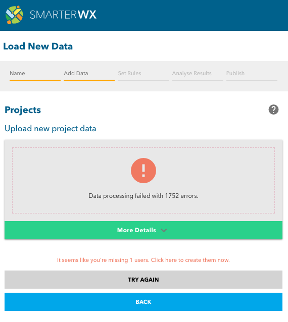
At the top of this view you will see a message saying “Data processing failed with 1752 errors.” This tells you how many records in your uploaded data were found to have an error. Clicking on the “More Details” bar will reveal details of the errors that were found. In this case there is an email for the “Project Primary Contact” missing from your organisation’s user list.
Having errors in your data will prevent you from uploading the data file. You must fix the errors and try again. You might also be shown warnings – warnings typically relate to the dates on your projects not matching the status. Some common examples include:
- a PROPOSED project where the END DATE is in the past
- a CONSTRUCTION project where the START DATE is in the future
Error Messages
This error message will be shown when uploading a projects file if an entry in the WorksClass field is not allowed. The error message will include the Source ID of the record and the value that was found.
The valid list of values for the WorksClass are:
WATER, GAS, ROAD RESURFACING, STORMWATER, ROAD CONSTRUCTION, STREET FURNITURE, GAS, POWER ABOVE GROUND, POWER BELOW GROUND, COMMUNICATIONS, FOOTPATH, LANDSCAPING/VEGETATION, OTHER
The full list of all fields and valid values can be found in How to Add your Data into SmarterWX.
Fix the value for the WorksClass field and reload your data file.
The error message “Email address does not match any user” will be shown if a record in your uploaded file has an email address that does not belong to a user in your organisation. You must set up all project managers as users before you can upload a project or exclusion zone file containing their email address.
The SourceID field is a unique identifier used by your organisation to identify a particular project or exclusion zone. If the same SourceID is found in an uploaded file for more than one record, the error “SourceID appears more than once” will be displayed.
The end date must be no earlier than the start date for a project or exclusion zone. This error indicates that the end date was found to be before the start date.
SmarterWX will reject any dates that are found to be more than 50 years in the future. This check is used to ensure that mistakes such as the wrong century are detected.
The start and end dates in your data must be valid dates. This error message indicates that the date could not be read.
The error message “Geometry is outside Organisation Region” will be seen when an uploaded feature is not within your organisation’s area of operation. The area of operation is shown as a green dashed outline on the search map.
SmarterWX is quite lenient with uploaded features allowing features to be loaded if any part of the feature is within about 50 meters of your area of operation.
Either correct the feature’s geometry to bring it inside your area of operation or contact the SmarterWX team to have your organisation’s area of operation updated.
The error message “Illegal geometry found – could not validate” is shown when the file uploader has not been able to parse the geometry for a particular feature.
This error is very rare but an example where this could be seen is when a polygon has multiple vertices with the same coordinates.
The error message “Invalid geometry type” will include an indication of the geometry type that was found. For example, “Invalid geometry type – POLYLINE”. All uploaded data should be in POLYGON format.
The error message “Errors occurred when attempting to convert spatial data” will be seen in the spatial data cannot be converted by the uploader. The uploaded data must be POLYGON data and the polygon must not contain any geometry errors.
The error message “File collection contains multiple layers – must contain exactly one” will be shown if an uploaded ZIP file is found to contain multiple data layers. Each ZIP file must contain only one layer – either exclusion zones or projects.
This error message indicates that the uploaded ZIP file does not contain all the necessary files for the selected file type.
The most common cause for this error is if the wrong file type was selected before uploading the file. Check to make sure you have selected the right file type.
Uploading an Esri Shapefile requires as a minimum the SHP, SHX and DBF files.
Uploading a MapInfo TAB file requires as a minimum the TAB and DAT files.
The Esri File Geodatabase is a complex file structure and contains many files.